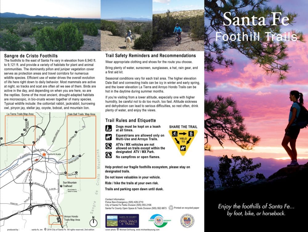
The Santa Fe Foothills Trails Map provides a comprehensive overview of the extensive trail systems in the hills surrounding Santa Fe. Incorporating the Dale Ball, La Tierra and Arroyo Hondo trail systems, the new Trails Map illustrates in a single map/brochure and demonstrates the connective relationship between the city and nearby trails. Important access points, junctions, and new connections were confirmed with the help of numerous public and private agencies in order to highlight Santa Fe’s rich recreational network and provide a safe and clear visitor experience.
The Foothills Trails Map identifies a system of over 62 miles of hiking and mountain bike trails extending across land owned by the City of Santa Fe, Santa Fe County, the National Forest Service, the Nature Conservancy, and private land. The map also provides route suggestions of varying lengths for different uses as well as safety and educational components relevant to the high desert ecosystem. Stakeholder input meetings were convened with representatives of local agencies, land owners, tourism / economic development departments, recreational users, and bike shop owners to review map content and legibility and to help promote this regional asset. In high demand, over 25,000 maps have been distributed in less than two years.
Through a joint effort with both Santa Fe County and the City of Santa Fe, Design Office developed a trailhead kiosk sign layout based on the successful Santa Fe Foothills Trails Map and incorporated Rules and Regulations and a Community Board for public posting. Sign panels are printed on 12-color dHPL (digital High Pressure Laminate) and the Community Board incorporates cedar wood paneling for posting flyers and notices. The sign frame is made of raw steel which was selected for its weathered, natural look and longevity. Design Office continues to work with Santa Fe County to plan additional kiosk sign locations at other City / County trailheads and develop a cohesive look across the trail system while better informing recreational users of the popular trail system.